
27.12.14
15.12.14
20.11.14
10.11.14
10.10.14
Refúgio de Treino
Olá Amigos, aqui está o Cartaz do nosso "Refúgio de Treino". Aguardamos os vossos contactos de modo a viverem na nossa companhia um grande fim de semana de lazer, desporto, gastronomia e companheirismo desportivo.
Temos preço para acompanhante. Este tem ao seu dispor o Circuito Termal, espaços de lazer, gastronomia, percursos pedestres e artesanato local.
 Possibilidade de preços mais baixos sem circuito termal. ;)
Temos preço para acompanhante. Este tem ao seu dispor o Circuito Termal, espaços de lazer, gastronomia, percursos pedestres e artesanato local.
9.10.14
14.9.14
E que tal roda 36???
Video do ano passado roda 36 btt.
Numa altura em que já saem estudos que indicam que na roda 29 se anda mais depressa podem ver aqui no link : (http://www.ecss.de/asp/2012_Bruges/Abstract_Display.asp?MyAbstractID=627)
Numa altura em que já saem estudos que indicam que na roda 29 se anda mais depressa podem ver aqui no link : (http://www.ecss.de/asp/2012_Bruges/Abstract_Display.asp?MyAbstractID=627)
18.8.14
24.7.14
31.5.14
Tu tens de ver isto BTT com Peter Sagan e Marco Fontana
Grande campanha de uma marca de bicicletas, a mostrar o novo modelo. Digam lá que não ficam com vontade de experimentar uma? Claro que os créditos vão para os pilotos das mesmas e para a equipa que fez o filme, está fantastico.
( ) - | |
% | |
Estimated Time: | |
Donate to SmartVideo! Global Preferences | |
7.5.14
Desafiando a gravidade
"By now most of you have seen this sick shot of Matt Hunter fighting gravity in front of Sterling Lorence's lens. A lot of you have suggested it's Photoshop, but Matt and the Anthill Films crew are here to show you that it's in fact just a bad ass move done right."
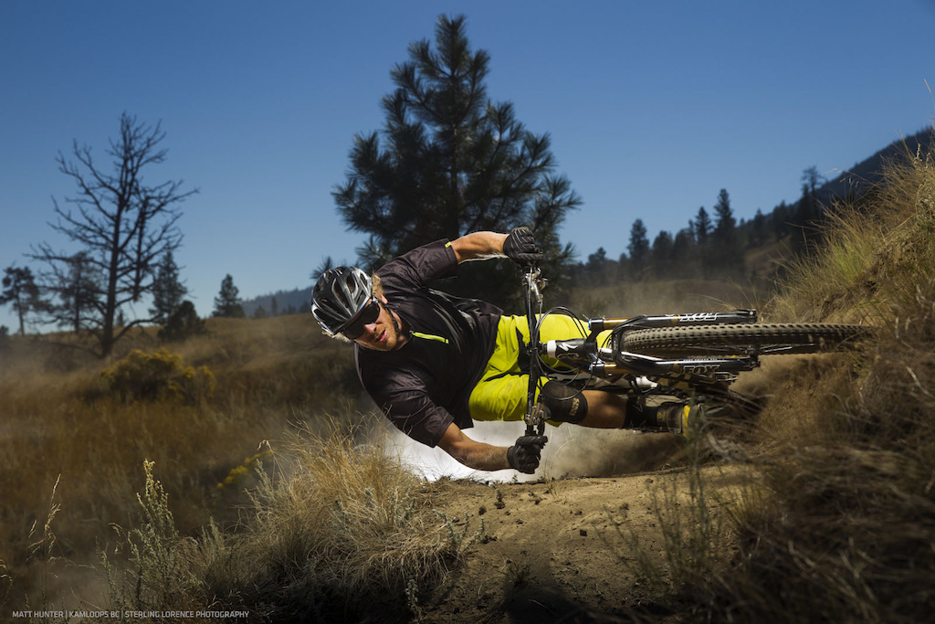
Parece fotoshop mas não é! Podem ver o video aqui: http://www.pinkbike.com/news/myth-buster-matt-hunter-video-2014.html
Parece fotoshop mas não é! Podem ver o video aqui: http://www.pinkbike.com/news/myth-buster-matt-hunter-video-2014.html
24.3.14
21.3.14
7.3.14
27.2.14
THREADING THE LINE
THREADING THE LINE
Story and Photographs by Dan Milner
“When you start the day with your forks dropped and your seatpost raised, you know it’s going to be a long one,” says Holger Meyer, about the thousand-meter climb ahead. We’re smiling, but inside we’re all anxious. What is scaring us most isn’t this climb, nor the two-hour hike-a-bike across a sketchy cliff face to come, or the horseflies waiting in the forest. It’s us not knowing what lies ahead, our ignorance of what we’ve let ourselves in for, and it caught us out on day one, leading us on an eight-hour jeeptrack safari from hell.
 |
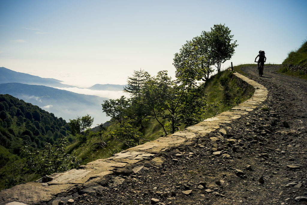
 Not for the faint hearted. Starting day 3 is a wake up call. Not for the faint hearted. Starting day 3 is a wake up call. |
We’re not to blame. The 400-Km long Alta Via dei Monti Liguri hiking trail we’re dipping into might be waymarked but it’s unknown among mountain bikers, despite it passing within a tyre’s knob of Finale Ligura’s Enduro World Series race. A basic website is all I have to plan our three-day hut trip, and the website’s rudimentary maps, resembling a squiggly line crayoned onto a napkin by a 4-year old, are little help. But its elevation profiles are. Armed with these, we might not know our whereabouts but at least we’ll know how many metres are involved, up and down. And the stats are appealing. Beginning in the mountains after a car-shuttle, our adventure will deliver 6000 m of descent over three days.
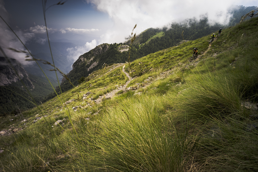 |
| Big open terrain and big open descents. The last descent of Day 2 to the refuge. |
And so this is how Holger, Karen Eller, Ollie Herren and myself find ourselves on day two of a100-Kilometre epic, pedaling up a rocky ancient military track towards the highest point on the Alta Via, the 2200m Monte Saccarello, with little idea of the trail ahead. On the plus side we haven’t had to carry our bikes much, yet.
We start our trip from the comfortable Piann’ del Arma hut, where our host, Rene, an ex-long distance HGV driver who looks like he likes a good meal or two himself, fuels us with piles of pasta. He loves the idea of us self-guiding along the Alta Via to Ventimiglia, our seaside finishing point. “Be careful though,” he chirps, as we leave next morning, “One section is impossible to ride!” It’s not clear exactly when the ‘impossible’ will surface, or how ‘impossible’ it may be. Non-bikers are prone to handing out warnings of impassable trails that often score a ‘perfect ten’ for mountain bikers, but we nod solemnly, agreeing to take care.
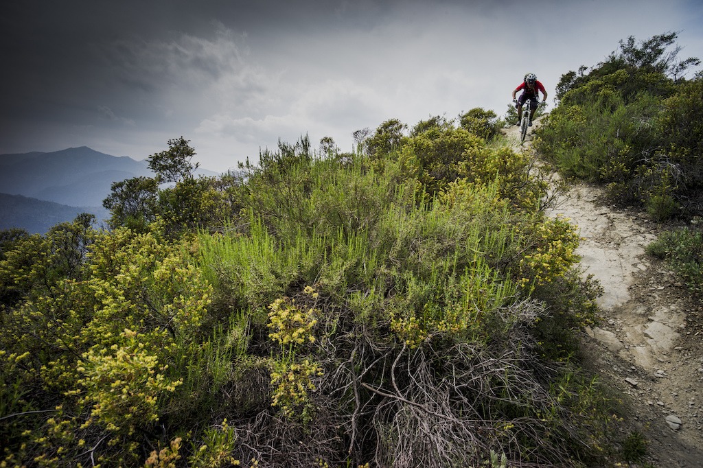 |
| Half way through the last day, Holger has the sea in his sights. |
We roll straight into singletrack suspended above a sea of cloud that laps the virtual shores of tumbling mountains, obscuring the bikini-strewn beaches far below. Mountains have their own way of doing things. In fact, our original plan to ride the Alta Via in April was scuppered by 60cm of snow. When we do hit the trail in mid June the snow has long gone, but this squiggly line on a map will wield other challenges, and today’s is sanity. Our initial singletrack joy soon deteriorates into a frustrating day of jeeptrack tedium, brightened only by a string of 19th century forts along our route. By the time we reach our 1260m Mendatica pass accommodation we’re grimy, tired and demoralized. Beer flows easily.
 |
| Old military roads are the perfect 7% gradient for gaining altitude. |
Following the French-Italian border, day two’s Alta Via threads its way through dozens of ruined military installations, connected by perfectly inclined old military roads. Despite the jeep track overdose on day one, none of us are complaining about using one to gain vertical on our morning’s ride out towards Monte Saccarello. The climb is big but it will have its rewards, notably a steep zig-zag descent of a hiking trail down from the peak, the endorphin-hit we all need for morale. Our rocky road becomes trail and we grind granny rings up the last 400 metres to the summit where, beneath a statue of the Virgin Mary, we fall from our bikes wanting to puke. She dips her hands, palm up, as if to be saying ‘well, what did you expect?”
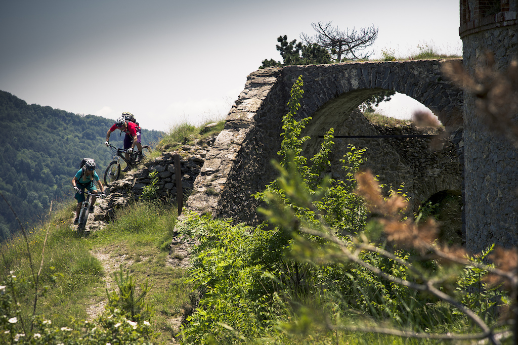 |
| Ancient castles tell of previous wars waged. |
Our gravity payback comes in a tight, steep trail full of technical rock gardens. When we are each catapulted out of the bottom of this 650-metre descent, broad grins overcome expressions of intense concentration. The next climb will now be easier to swallow. As we pedal onwards, Mediterranean thorny scrub overpowers the Alpine forests, and our trail becomes dry and loose. The descent to our second night’s accommodation, the 1545m Cardella hut, is fast and furious. Now with a total 55km of trail and 2500m of climbing behind us we’ve earned this reward. Despite the risk of pinch flats or shedding skin on the sharp rocks either side, we blast our way down to a hearty dinner, a sluice of beers and a dorm bunkbed.
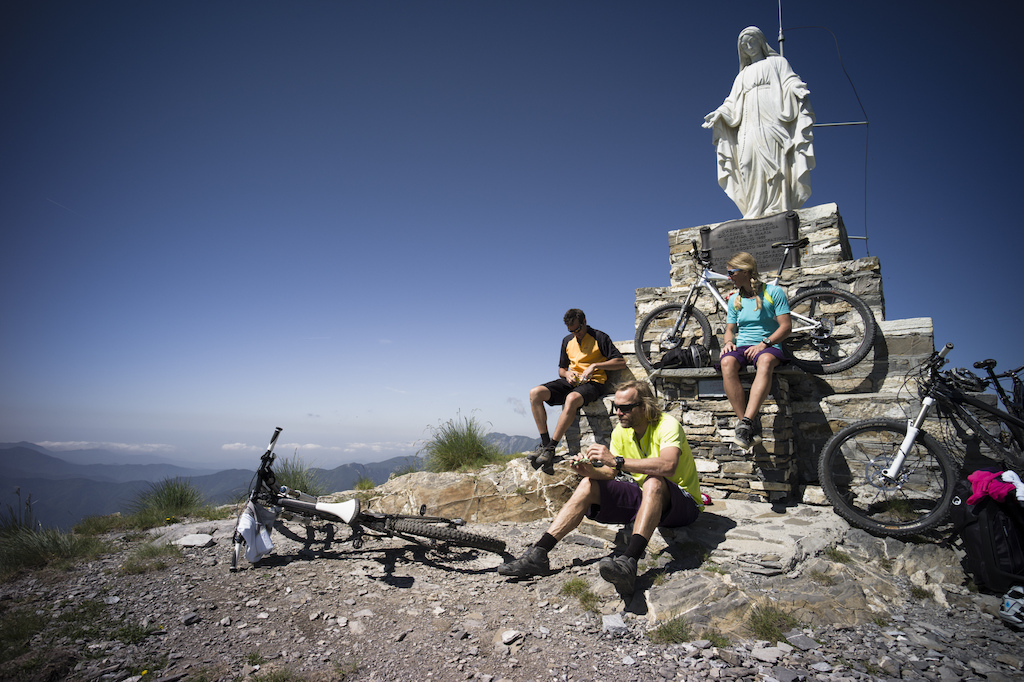 |
| "Well what did you expect?" did you think it would be easy? |
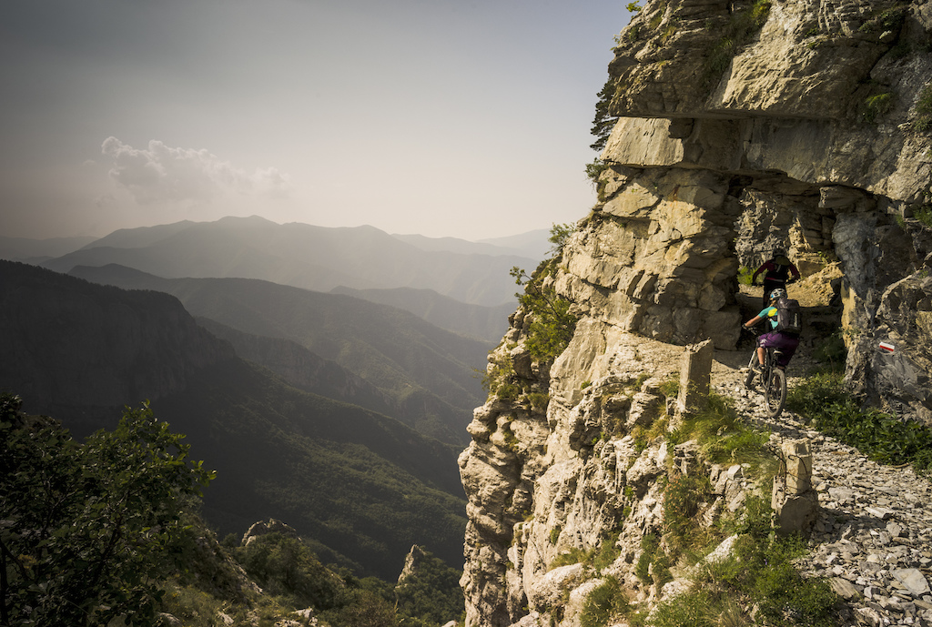
We start day three, a 45-Kilometre ride that climbs 1200m but descends 3000m all the way to the sea at Ventimiglia, with another warning. Our Italian refuge host, otherwise enthusiastic for everything life can throw at him, points to a ribbon of trail in the distance. “This part is impossible by bike,” he says, echoing Rene’s caution, and recommending we follow the traditional Alta Via to the French-Italian border ridge instead. From our vantage point at the refuge, we agree. The trail appears nothing more than a fault line, a scar across a vertical cliff face. But as we climb out of the refuge we get a better look at the ‘impossible’ option, a two-metre wide ledge hacked out of the cliff face that enabled Italian troops to move undetected by the French. It’s a tricky decision, full of commitment. At best it risks some serious bike portage, at worst, pain. We opt for the ledge. Adventure is after all, full of unknowns.
This ledge is just another line on a map, but like the line we’ve followed for three days, it precariously juggles pleasure and pain. Like the Alta Via that is behind us, or the last 40 Kilometres of fast paced singletrack ahead that day, this line balances great riding and adventure, threading its way through big mountains and between different countries. We pedal on. It’s a line worth threading.
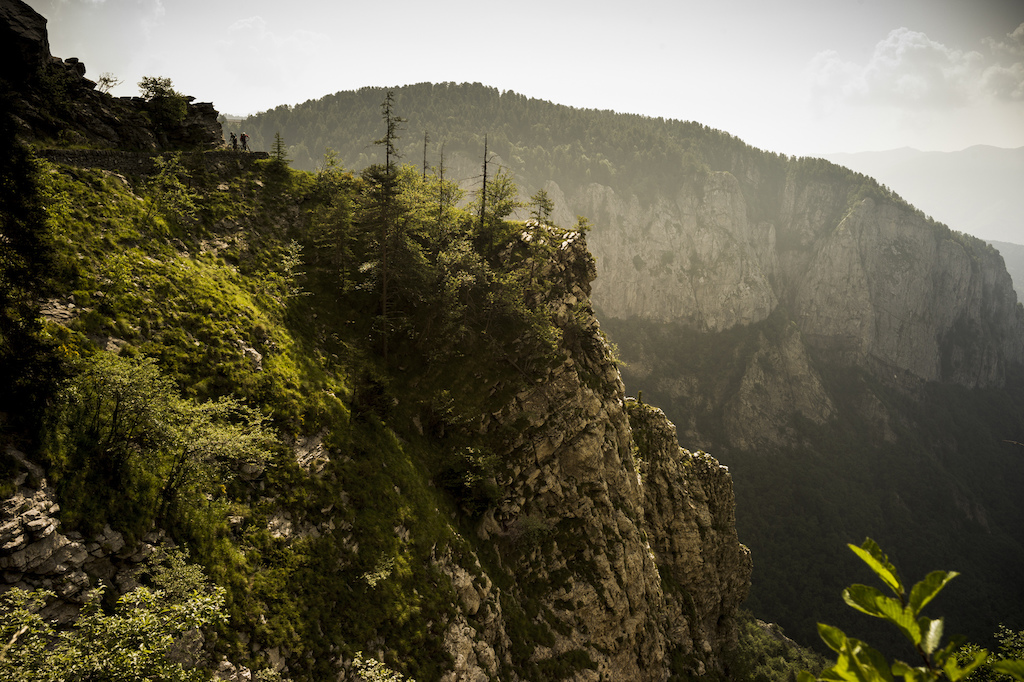 |
| Another day, another exposed trail. |
HOW: the Alta Via (www.altaviadeimontiliguri.it/portale) has 43 hiking stages starting from Ventimiglia. We rode the western 100 Km starting in the mountains to give a net descent through the 3 days. Skip the first day and just ride stages 6 through 1, starting at Colle Mendatica, to avoid our first day of boring jeep track. Refuge accommodation costs 40 Euros half board. Info on website. The trail is well marked and easy to follow without a map. Despite rumors, 1:50 000 Maps of the route do actually exist, (Italian Instituto Geografico Centrale, map no. 14 and 15).
WHEN: Best from May to October, with May and September being ideal months to ride.
WHAT: Carry all emergency essentials such as cables, chain links, spare tube and patches. You’ll need a waterproof (these are real mountains) and an extra layer for the evening but that’s it: The refuges provide linen. A 30 L backpack is plenty, but carry a 3L water reservoir. There is no water or food once on the trail except at refuges.
GETTING THERE: Closest airports are Nice, Genova or Turin. Shuttle your bikes to Colle Mendatica and leave your vehicle in Ventimiglia, using a train and then taxi to get back up to the refuge the night prior to the start. If you have two vehicles this become simple.
This Report is from PINKBIKE.com
21.2.14
Medicine of Cycling
Medicine of Cycling (lista de reprodução)
http://www.youtube.com/playlist?list=PLepHs0thoryOMf-AwPit9IM-6DEmkHCpj
http://www.youtube.com/playlist?list=PLepHs0thoryOMf-AwPit9IM-6DEmkHCpj
4.2.14
Campeonatos do Mundo de CicloCross 2014
Como podem ver em média cada atleta deve dar dois tombos.
No youtube tem lá o resumo também das outras categorias.
31.1.14
16.1.14
Como fazer uma capa para o capacete
Um video com a participação do Hermida a explicar como se faz uma capa transparente para o capacete.
Subscribe to:
Posts (Atom)